
Hatcher Pass
|
|
We continue to be in a unique avalanche paradigm, with areas of very good stability mixed with specific locations that contain glide avalanche hazards, which are unpredictable and dangerous, but are fortunately fairly easy to identify and avoid.
Natural glide avalanches are unlikely, but may be possible in isolated occurrence today. Any glide avalanche will be large enough to bury, injure or kill a person. Avoid being under, on, or near glide cracks and old glide activity. Avalanches may run farther than you think.
The avalanche hazard is LOW today, due to the observed reduction in natural glide avalanche activity over the last two weeks, but glide avalanches are still possible and threaten many common travel routes in the backcountry and along the road corridor. Look up and steer clear.
The avalanche hazard is expected to remain the same with no rapid or large changes in the weather through the weekend.
JAN 7 – HPAC presents at Tuesday Night’s at SkiAK. Get to know the staff, how they report mountain conditions, the importance of public real time observations and take in some lessons learned from past seasons. click HERE.
JAN 11 – Get ready for the annual free avalanche rescue workshop, Jan 11, hosted by the Hatcher Pass Snow Riders Club, HPAC and CNFAIC. Stay tuned for more information coming soon…
Click HERE to view more events

| |
|
|
|
|
|
| Travel Advice | Generally safe avalanche conditions. Watch for unstable snow on isolated terrain features. | Heightened avalanche conditions on specific terrain features. Evaluate snow and terrain carefully; identify features of concern. | Dangerous avalanche conditions. Careful snowpack evaluation, cautious route-finding, and conservative decision-making essential. | Very dangerous avalanche conditions. Travel in avalanche terrain not recommended. | Extraordinarily dangerous avalanche conditions. Avoid all avalanche terrain. |
| Likelihood of Avalanches | Natural and human-triggered avalanches unlikely. | Natural avalanches unlikely; human-triggered avalanches possible. | Natural avalanches possible; human-triggered avalanches likely. | Natural avalanches likely; human-triggered avalanches very likely. | Natural and human-triggered avalanches certain. |
| Avalanche Size and Distribution | Small avalanches in isolated areas or extreme terrain. | Small avalanches in specific areas; or large avalanches in isolated areas. | Small avalanches in many areas; or large avalanches in specific areas; or very large avalanches in isolated areas. | Large avalanches in many areas; or very large avalanches in specific areas. | Very large avalanches in many areas. |
No new avalanches observed this week.
This includes no new glide avalanches. Some glide cracks have expanded. It appears that glide activity has subsided this week, however you should still be extremely cautious and avoid any areas with glide cracks.
People are still getting out and poking around the backcountry looking for isolated pockets of good riding, which do exist. There has been a decent amount of snow machine traffic along the Archangel motorized access with no resulting avalanches observed.
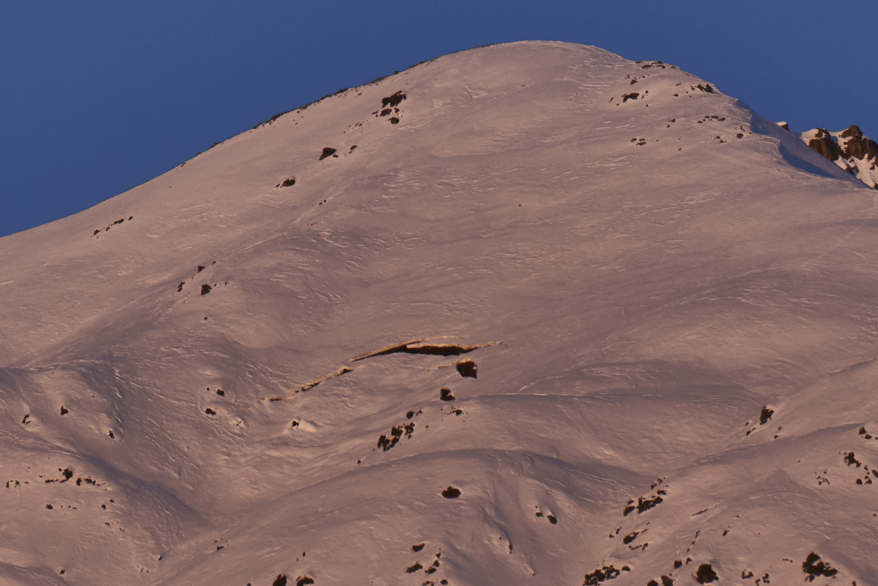
12/20/2019 – Skyscraper, SSE, 4000´. Untrustworthy, expanding glide crack.

This picture, taken last week, identifies a known glide crack which has continued to expand this week on the SW face of Marmot, hanging above the motorized trail, and common traverse back to the Fishhook Lot.
Hatcher pass continues to suffer from widespread wind damage to the snow surface from a wind event two weeks ago. The best “recycled” powder is in the mid elevations bands in areas that have more wind protection. Recent cold temperatures and the faceting process are slowly improving riding conditions in the top 6-8 inches of the snow surface.
| Signal Word | Size (D scale) | Simple Descriptor |
| Small | 1 | Unlikely to bury a person |
| Large | 2 | Can bury a person |
| Very Large | 3 | Can destroy a house |
| Historic | 4 & 5 | Can destroy part or all of a village |
We are currently down-rating this hazard from last weekend due to a reduction in observed glide activity over the past two weeks. Glide avalanches are still possible, but we think the likelihood is lower today.
Glide avalanches are unlikely, but could occur on all aspects, at mid to upper elevations. As an additional heads up, consider the isolated possibility of a mid elevation glide crack releasing and running out into the low elevation band. Glide avalanches release the entire snowpack depth as a unit, are often large volume, and can run farther than you may anticipate. Fortunately, glide cracks are easy to identify and therefore fairly easy to avoid. See pictures above and in this seasons observations for examples glide cracks, also known as “brown frowns”, and glide avalanches.

An older glide avalanche on the southern aspect of Hatch Peak is highly visible from the road and gives you a sense of the scale of this hazard.
Given the uncertainty about the timing of glide avalanche release, continue to play it safe and avoid this high consequence hazard. Avoid travel under, on, or near any areas with glide cracks or old glide activity. There are a number of glide cracks hovering over common travel routes at HP. Make sure to look up and avoid these hanging hazards. This includes the SW face of marmot, above the motorized trail, and the SE face of Skyscraper, over the winter road to HP proper.
Some glide cracks have been expanding over the last couple of weeks, and will be impossible to predict whether or not they release. Some glide cracks have been filled in by snow earlier in the season and wind blown snow from two weeks ago, and therefore may be difficult to identify their presence.
Colder temperatures are forecasted through the weekend with calm to light winds. Starting Sunday we may get some clouds as a new low pressure system affects our area. This may bring limited amounts of snow, and is not expected to be a large snow producer. The avalanche hazard will stay the same with no rapid or large changes in the weather over the weekend.
NWS Rec Forecast here.
NWS point forecast here.
State Parks Snow Report and Motorized Access information here.


