
Hatcher Pass
|
|
Today a Moderate Hazard for Small Wind Slabs exists at the upper elevation, on leeward, South to West aspects, on slope 35° and steeper.
A Low Hazard exists for Dry Loose Avalanches at all elevations, on all aspects, on slopes 40° and steeper. Be cautious around loose dry avalanches which could wash or carry you, into terrain traps, compounding the hazard.
Join us today at the Gold Mint Lot at HP from 11 am-1:30 pm for our annual FREE RESCUE WORKSHOP. Come practice your companion rescue skills. Sponsored by the HP Snowriders, HPAC, CNFAIC, ANSP, and Black Diamond Anchorage. Bring your rescue gear and bundle up. It’s gonna be cold!
Come support HPAC at our 11th Annual Cabin Fever Reliever and Fundraiser at the Moose Lodge in Palmer, Saturday, Feb 8 at 5:30 pm. Live music, silent auction, local food and libations. Buy your tickets online NOW at: https://cabinfeverreliever.bpt.me

| |
|
|
|
|
|
| Travel Advice | Generally safe avalanche conditions. Watch for unstable snow on isolated terrain features. | Heightened avalanche conditions on specific terrain features. Evaluate snow and terrain carefully; identify features of concern. | Dangerous avalanche conditions. Careful snowpack evaluation, cautious route-finding, and conservative decision-making essential. | Very dangerous avalanche conditions. Travel in avalanche terrain not recommended. | Extraordinarily dangerous avalanche conditions. Avoid all avalanche terrain. |
| Likelihood of Avalanches | Natural and human-triggered avalanches unlikely. | Natural avalanches unlikely; human-triggered avalanches possible. | Natural avalanches possible; human-triggered avalanches likely. | Natural avalanches likely; human-triggered avalanches very likely. | Natural and human-triggered avalanches certain. |
| Avalanche Size and Distribution | Small avalanches in isolated areas or extreme terrain. | Small avalanches in specific areas; or large avalanches in isolated areas. | Small avalanches in many areas; or large avalanches in specific areas; or very large avalanches in isolated areas. | Large avalanches in many areas; or very large avalanches in specific areas. | Very large avalanches in many areas. |
The last observed avalanches were on January 4.
Pinnacle peak avalanche observation here.
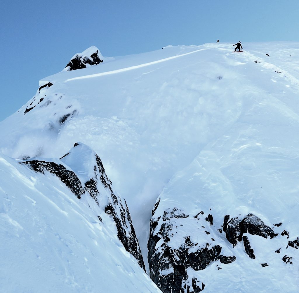
1/4/2020 – Human triggered persistent slab avalanche, 1 foot deep, on Pinnacle peak, Northwest, 5100′. Relatively small slab avalanche, but with serious secondary consequences if caught, since the avalanche ran over a cliff.
1/4/2020 – Human triggered persistent slab avalanche on Far Side Variation, Northwest, 4700′. Also a relatively small slab avalanche, but large enough to injure a person.
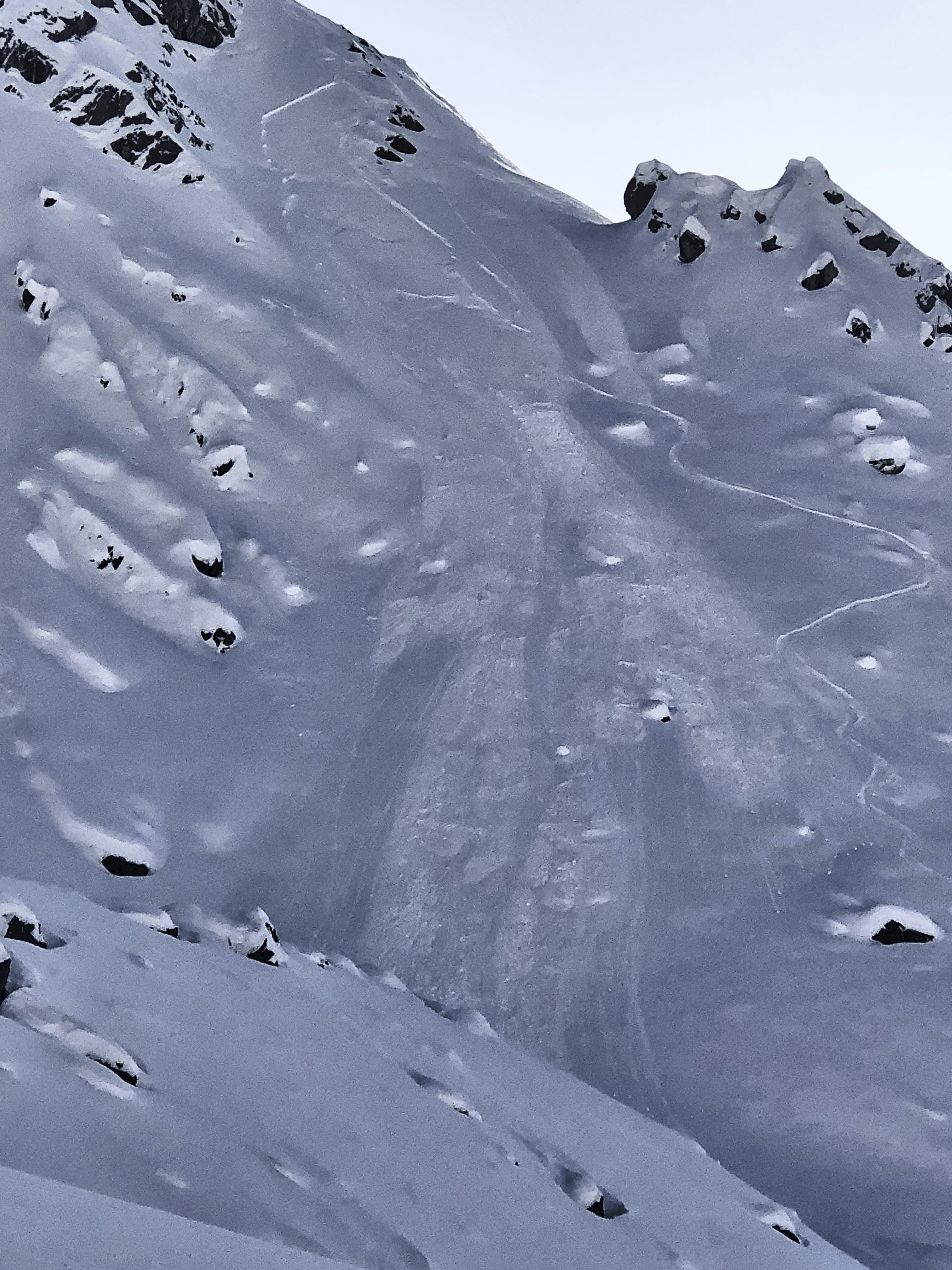
The last natural avalanches occurred on New Years. Pictured below is an example of the avalanches that naturally released during and just after the new years storm.

Microdot, North, 4800′. New Years avalanche cycle. Numerous slopes were wind loaded and failed naturally.
| Signal Word | Size (D scale) | Simple Descriptor |
| Small | 1 | Unlikely to bury a person |
| Large | 2 | Can bury a person |
| Very Large | 3 | Can destroy a house |
| Historic | 4 & 5 | Can destroy part or all of a village |
Triggering a small, soft slab avalanche, 3-8″ deep, will be possible today in specific terrain, on leeward, South to West aspects, at upper elevation.
While strong winds have persisted in Palmer and Wasilla and the Matanuska Valley over the last two days, Hatcher Pass winds have remained calm to light up until last night. Winds overnight at the Marmot weather station (4500′) produced peak gusts for a short period of time, 15-29 mph, for 5 hours. Winds have settled down this morning and are expected to remain light, NE 6-12 mph through the day.
East Northeast winds overnight have transported available low density snow and deposited fresh wind drifted, cohesive slabs on leeward aspects. These slabs are sitting on persistent, faceted, weak snow grains. Slabs may release above you and propagate further than expected due to the faceted, weak layer problem. Visual clues, such as smooth snow pillows may assist in identifying problem areas. Pole, or probe testing, will also help you to identify an upside down snowpack, where stiffer snow sits over weaker snow. Cracking and collapsing are bulls eye clues for this avalanche problem.
Yesterday’s winds were calm for most of Hatcher Pass, however, strong winds in the Matanuska Valley may have affected the southeastern boarder of Hatcher Pass. Some wind flagging was observed along the Arkose ridgeline. If you venture into this area today, anticipate this avalanche problem to be more severe until proven otherwise. This means slabs may be easier to trigger and may be bigger than what we see in the core portion of our forecast area today.

Wind loading yesterday in the Matauska Valley.
If the winds continue to remain light, expect this hazard to slowly improve through the weekend.
| Signal Word | Size (D scale) | Simple Descriptor |
| Small | 1 | Unlikely to bury a person |
| Large | 2 | Can bury a person |
| Very Large | 3 | Can destroy a house |
| Historic | 4 & 5 | Can destroy part or all of a village |
Small loose dry avalanches will be possible to human trigger, on any aspect, on slopes 40° and steeper. Approximately 6″ of loose snow sits on firm, smooth surfaces. While these types of avalanches may not be large enough to injure you, they may have enough volume to catch you and wash or drag you into terrain traps, such as rocks and cliffs, which will compound the hazard.
Ski cutting can be a safe and effective technique for mitigating this hazard, if properly executed.
Glide Avalanches
The last observed glide avalanche release that we know about was on December 7 on the southeast face of Hatch Peak. This activity is a month old, and seems to be in dormancy. However, glide cracks are still present and could release at any time. Many glides are now barely visible from this week’s new snow. Caution should be taken to not ski/ride into these terrain traps. It’s important to note that glide releases can happen in warm or cold weather, are not temperature dependent, and predictability is next to impossible. Any glide avalanche will be large and capable of burying, injuring, and/or killing a person. We recommend avoiding being on or under any locations with glide cracks.
Cornices
Due to plentiful snow this season and strong wind events, cornices are overhanging and large. Cornices are difficult to predict the timing of natural release. There have already been a few releases this season involving people and old cornice debris and large chunks are present at the base of some slopes. If traveling under cornices, limit the time of your exposure. If you are approaching cornices from behind, use extreme caution, gain a safe viewpoint to identify safe entries onto slopes below, and do not step out on overhanging cornice features.
Cornice failures may be large, and the mass of a cornice may be large enough to injure or kill a person. Cornices may also entrain more loose snow, which could carry you into additional hazards.
It’s been awhile since we’ve seen an entire week of below zero and single digit temps! Temps averaged -1.3ºF at 3550′ with a low of -9ºF.
Temps averaged -1ºF at 4500′ with a low of -8ºF.
Cold temperatures are in the forecast through the weekend and into next week.
A strong pressure gradient has been driving outflow winds through the Matanuska Valley for a couple days, and this will persist today and through the weekend.
A low pressure system moving into Southcentral on Sunday will bring a change with some clouds. The pressure gradient between this incoming system and the high pressure firmly entrenched inland will continue to produce the Matanuska Valley strong outflow winds which may effect Hatcher Pass. The incoming low pressure system is not expected to bring much snow, with perhaps an inch or two od accumulation on Sunday.
NWS Rec Forecast here.
NWS point forecast here.
State Parks Snow Report and Motorized Access information here.


