Hatcher Pass
|
 Archives
|
 The Bottom Line
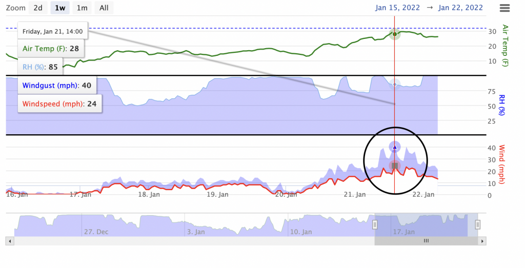
5″ of new snow has accumulated early this morning combined with strong SE winds gusting 30-40 mph for 11 hours.
Small to large winds slabs will be likely to human trigger primarily on southwest to west to north aspects in addition to cross-loaded features at mid and upper elevation on slopes above 35º. Naturals avalanches are possible. Wind slabs will have the potential of stepping down into the persistent slab.
Small to large persistent slabs will be possible to human trigger on all aspects at mid and upper elevation on slopes above 30º. Natural avalanches are unlikely today.


| |
 |
|
 |
 |
|
| Travel Advice | Generally safe avalanche conditions. Watch for unstable snow on isolated terrain features. | Heightened avalanche conditions on specific terrain features. Evaluate snow and terrain carefully; identify features of concern. | Dangerous avalanche conditions. Careful snowpack evaluation, cautious route-finding, and conservative decision-making essential. | Very dangerous avalanche conditions. Travel in avalanche terrain not recommended. | Extraordinarily dangerous avalanche conditions. Avoid all avalanche terrain. |
| Likelihood of Avalanches | Natural and human-triggered avalanches unlikely. | Natural avalanches unlikely; human-triggered avalanches possible. | Natural avalanches possible; human-triggered avalanches likely. | Natural avalanches likely; human-triggered avalanches very likely. | Natural and human-triggered avalanches certain. |
| Avalanche Size and Distribution | Small avalanches in isolated areas or extreme terrain. | Small avalanches in specific areas; or large avalanches in isolated areas. | Small avalanches in many areas; or large avalanches in specific areas; or very large avalanches in isolated areas. | Large avalanches in many areas; or very large avalanches in specific areas. | Very large avalanches in many areas. |
Several small, natural wind slabs were observed on Friday on cross-loaded East aspects between 3500-4000′. There is a high likelihood that more naturals occurred but we did not see them due to poor visibility.
On Friday, one small human triggered wind slab was observed near ridgetop on the SW aspect of Marmot.
| Signal Word | Size (D scale) | Simple Descriptor |
| Small | 1 | Unlikely to bury a person |
| Large | 2 | Can bury a person |
| Very Large | 3 | Can destroy a house |
| Historic | 4 & 5 | Can destroy part or all of a village |
8-9″ of new snow from 1/20-22 combined with strong winds on Friday gusting ESE/SE 28-40 mph for 11 hours has transported a significant amount of snow and built wind slabs 10-16″ thick. These wind slabs will be likely to human trigger on southwest to west to north aspects, as well as any cross-loaded features, at mid and upper elevation on slopes above 35º. Natural avalanches are possible today.
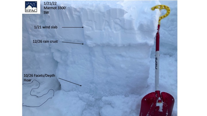
Wind slabs are sitting on Dec. 26 rain crusts and will most likely fail within the new snow, above and below the crust. It will also be possible for wind slabs to step down into the persistent slab, increasing the size and consequence of the avalanche.
Wind slabs will be easy to identify. Look for hard snow sitting over weaker snow, smooth and rounded or lens shaped features. Shooting cracks or whumping are signs of instability and indicators of this avalanche problem.
Expect the wind slab problem to improve within 24-48 hours after winds subside.
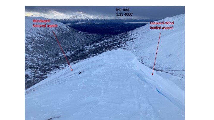
The picture below shows the stark difference on Marmot between windward (rocks visible) and leeward aspects.
The graph below shows strong ESE/SE gusts for 11 hours on Friday and Saturday morning.
| Signal Word | Size (D scale) | Simple Descriptor |
| Small | 1 | Unlikely to bury a person |
| Large | 2 | Can bury a person |
| Very Large | 3 | Can destroy a house |
| Historic | 4 & 5 | Can destroy part or all of a village |
Persistent slabs will be possible to human trigger in specific terrain at mid and upper elevation on slopes above 30º. The most likely spots to trigger a slab will be SW to W to NE aspects or anywhere a slab it sitting on top of the Dec 26 rain crust(s) on top of weak facets and/or depth hoar.
The distribution of this problem is more complex. Although poor structure is widespread, previously wind loaded slopes will be more likely locations to trigger a slab avalanche today.
•SE to SW aspects wind loaded from the Bora (Jan. 2-3) wind event.
•N,NW,NE aspects wind loaded on Jan 13-14
•SW,W,NW,N aspects wind loaded on Jan 21-22
The flaws in the snowpack are widespread, but the problem locations are specific. The flaws are buried combinations of crusts and facets (sugar snow). The locations include recently wind loaded areas mentioned above at mid to upper elevation.
The pit below shows the poor structure of the snowpack. We are consistently seeing propagation on a thin layer of facets (weak sugary snow) above and/or below the rain crust.
Avalanche behavior may be difficult to predict. The average depth for persistent slab avalanches is expected to be 1.5 to 3 feet deep.
Pole/probe tests and formal stability tests will help you identify this problem. Whumping and shooting cracks will be red flags for this avalanche problem but may not be present prior to triggering an avalanche.
If you head into avalanche terrain today, utilize strict safety travel protocols, travel one at a time from safe zone to safe zone, only have one person on slope at a time, ensure all members of your party are carrying and know how to use beacons, shovels and probes, and avoid slopes with terrain traps.
As of 5am HP has received 4″ of new snow early this morning with strong SE winds gusting 30-40 for 11 hours.
HP received approximately 3-4″of new snow on Thur/Friday.
Temperatures will rise above freezing through Monday.
NWS AVG Forecast here.
NWS Rec Forecast here.
NWS point forecast here.
State Parks Snow Report and Motorized Access information here.