
Hatcher Pass
|
|
This information is a Conditions Update. Danger ratings are only issued with avalanches advisories. The next avalanche advisory is scheduled for Saturday March 9, 2019.
Previous avalanche advisories HERE
MIDWEEK SNOW AND AVALANCHE CONDITIONS SUMMARY
Temperatures have cooled off after the unseasonably warm weather last week which has momentarily locked up the snowpack. Human-triggered and natural avalanches will be unlikely today. This does not mean NO hazard.
The last reported human-triggered avalanches occurred back on February 23rd near Dnigi Hut and in Lone Tree Gulch. Evidence of a natural cornice-fall triggered avalanche large enough to bury or injure a person was observed on the north side of Granite Mountain this week, but the exact time and date are unknown. The cornice fall likely occurred during the warm temperatures last week.
Hatcher Pass has received slightly over an inch of new snow this week. While the most popular areas are heavily tracked, untracked lines can still be found with a little extra work, creativity, or perhaps fuel. The best snow for skiing and riding will generally be found on shaded aspects, although good skiing has been found recently on east to southeast aspects as well. South to southwest aspects have a 3-4” sun crust.
This report is a mid-week conditions update, so please be sure to check hpavalanche.org for advisories on Saturdays and follow the HPAC Facebook for updates. Help us keep tabs on the Hatcher Pass area! If you see any avalanche activity send us an observation HERE. Thank you to everyone who has already submitted observations this season – you can see those HERE!

Even more remote areas like Purches Creek are heavily tracked, but lots of untracked lines can still be found.

Nearly all solar aspects have some kind of wet loose avalanche debris from warming last week.

3-4″ sun crust found on south to southwest aspects
Below: Join us TONIGHT in partnership with the Anchorage chapter of American Society of Mechanical Engineers in hosting Dr. Edward Adams of Montana State University for a presentation on the micro-structures of snow and how it relates to the snow cover we love to play on.

| |
|
|
|
|
|
| Travel Advice | Generally safe avalanche conditions. Watch for unstable snow on isolated terrain features. | Heightened avalanche conditions on specific terrain features. Evaluate snow and terrain carefully; identify features of concern. | Dangerous avalanche conditions. Careful snowpack evaluation, cautious route-finding, and conservative decision-making essential. | Very dangerous avalanche conditions. Travel in avalanche terrain not recommended. | Extraordinarily dangerous avalanche conditions. Avoid all avalanche terrain. |
| Likelihood of Avalanches | Natural and human-triggered avalanches unlikely. | Natural avalanches unlikely; human-triggered avalanches possible. | Natural avalanches possible; human-triggered avalanches likely. | Natural avalanches likely; human-triggered avalanches very likely. | Natural and human-triggered avalanches certain. |
| Avalanche Size and Distribution | Small avalanches in isolated areas or extreme terrain. | Small avalanches in specific areas; or large avalanches in isolated areas. | Small avalanches in many areas; or large avalanches in specific areas; or very large avalanches in isolated areas. | Large avalanches in many areas; or very large avalanches in specific areas. | Very large avalanches in many areas. |
The last reported human-triggered avalanches occurred back on February 23rd near Dnigi Hut and in Lone Tree Gulch. Observers on Monday found a large natural cornice-fall triggered slab avalanche on the north aspect of Granite Mountain. at~5000′. It ran to 4200′ (This is the bowl northwest of High Grade Pass). Time and date of the event are unknown. The cornice fall likely occurred during the warm temperatures last week.
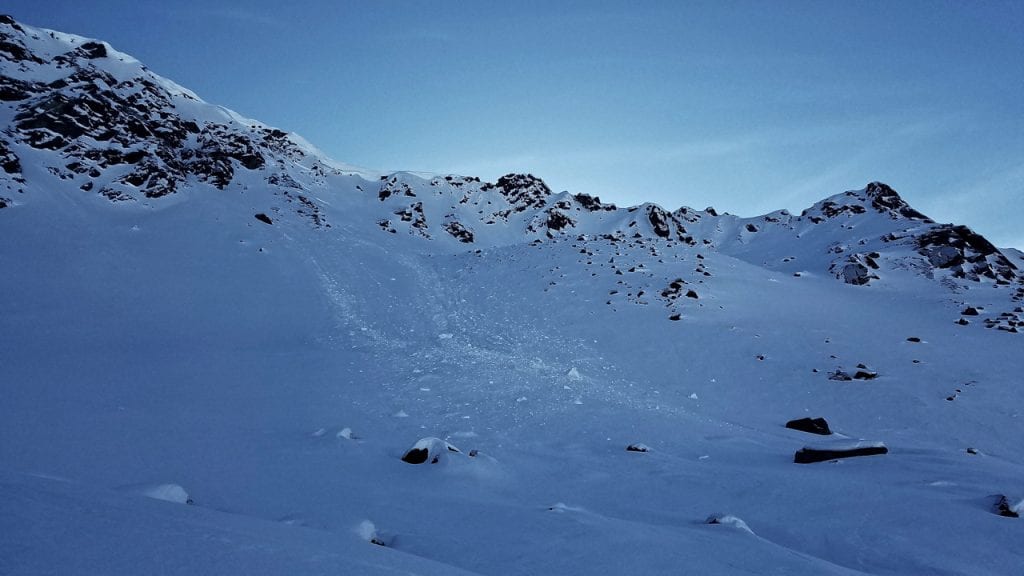
HS-NC-R1-D2 Large natural cornice-fall triggered slab avalanche on the north aspect of Granite Mountain, ~5000′, ran to 4200′ (bowl northwest of High Grade Pass). Time and date of event unknown.
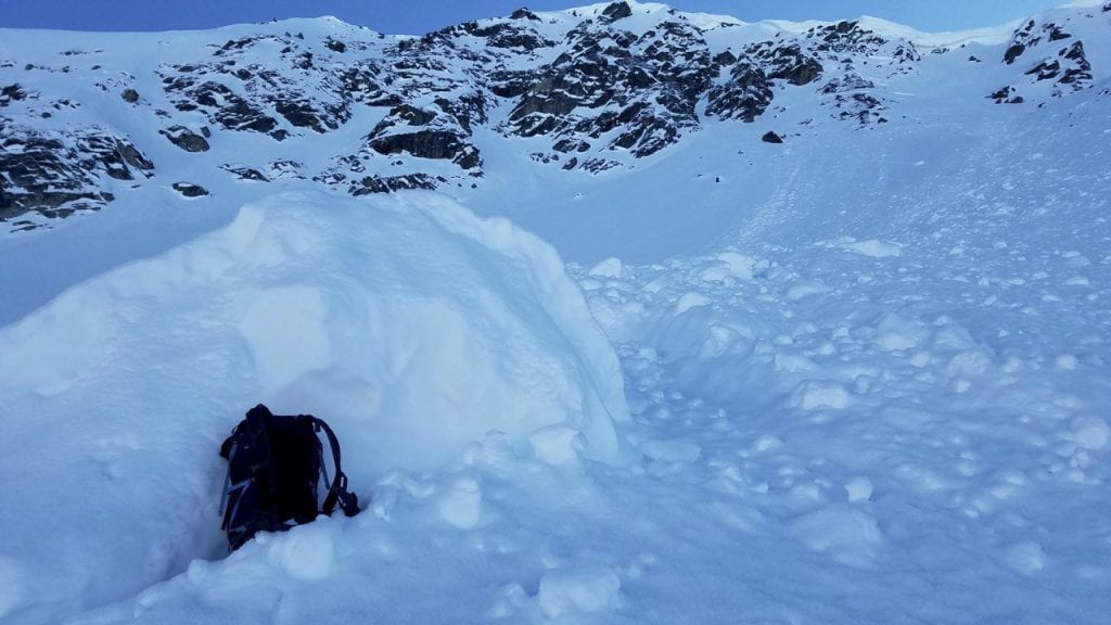
Closer view of avalanche above, showing blocks of debris larger than a person.
Weather History
Weather at 3450′ since Saturday 2/2:
Temperatures averaged 21°F, with a low of 13°F and a high of 31°F.
Winds averaged N 3 mph, max 6 mph. Max gusts recorded were N 9 mph .
There has been about 1″ new snow recorded at Independence Mine.
Weather at 4500′ since Saturday 2/2:
Temperatures averaged 17°F, with a low of 12°F and a high of 25°F.
Winds averaged E to SSE 3 mph, max 9 mph. Gusts averaged E to SSE 6 mph, max gust 13 mph.
Forecast Weather
Stay tuned to the NOAA point forecast for an updated weather forecast each day. The best way to see if it’s snowing in Hatcher Pass is to look at the webcam snow stake HERE and the Independence Mine SNOTEL site HERE
State Parks Snow Report and Motorized Access information can be found here.


