
Hatcher Pass
|
|
Conditions have transitioned from a winter weather pattern to spring-like conditions and a diurnal pattern of overnight freezing and afternoon thawing.
Low avalanche hazard for wet loose and dry loose avalanches at all elevations. Human triggered avalanches will be unlikely. Low hazard does not mean NO hazard.
As temperatures rise in the afternoon, pay attention to an increasing possibility for human triggered wet loose avalanches on S through SW aspects, on steep slopes above 40°, at all elevations.
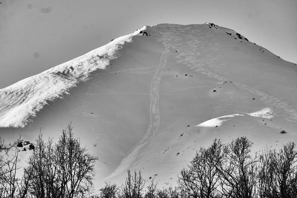
Excellent skiing and riding conditions still exist at HP, but further travel will be required to find untouched terrain. The best, coldest snow, will be found on the shadier aspects.
Below: Come join us for an evening of fun learning about snow science with ASME!
| |
|
|
|
|
|
| Travel Advice | Generally safe avalanche conditions. Watch for unstable snow on isolated terrain features. | Heightened avalanche conditions on specific terrain features. Evaluate snow and terrain carefully; identify features of concern. | Dangerous avalanche conditions. Careful snowpack evaluation, cautious route-finding, and conservative decision-making essential. | Very dangerous avalanche conditions. Travel in avalanche terrain not recommended. | Extraordinarily dangerous avalanche conditions. Avoid all avalanche terrain. |
| Likelihood of Avalanches | Natural and human-triggered avalanches unlikely. | Natural avalanches unlikely; human-triggered avalanches possible. | Natural avalanches possible; human-triggered avalanches likely. | Natural avalanches likely; human-triggered avalanches very likely. | Natural and human-triggered avalanches certain. |
| Avalanche Size and Distribution | Small avalanches in isolated areas or extreme terrain. | Small avalanches in specific areas; or large avalanches in isolated areas. | Small avalanches in many areas; or large avalanches in specific areas; or very large avalanches in isolated areas. | Large avalanches in many areas; or very large avalanches in specific areas. | Very large avalanches in many areas. |
Since Monday, a significant warming trend has contributed to wet loose activity at Hatcher Pass. Human triggered and natural wet-loose were observed on SE through SW aspects on steep slopes, above 40º, at all elevations, mostly in the afternoon. These avalanches ranged from D1-D2, large enough to bury, injure, or kill a person.
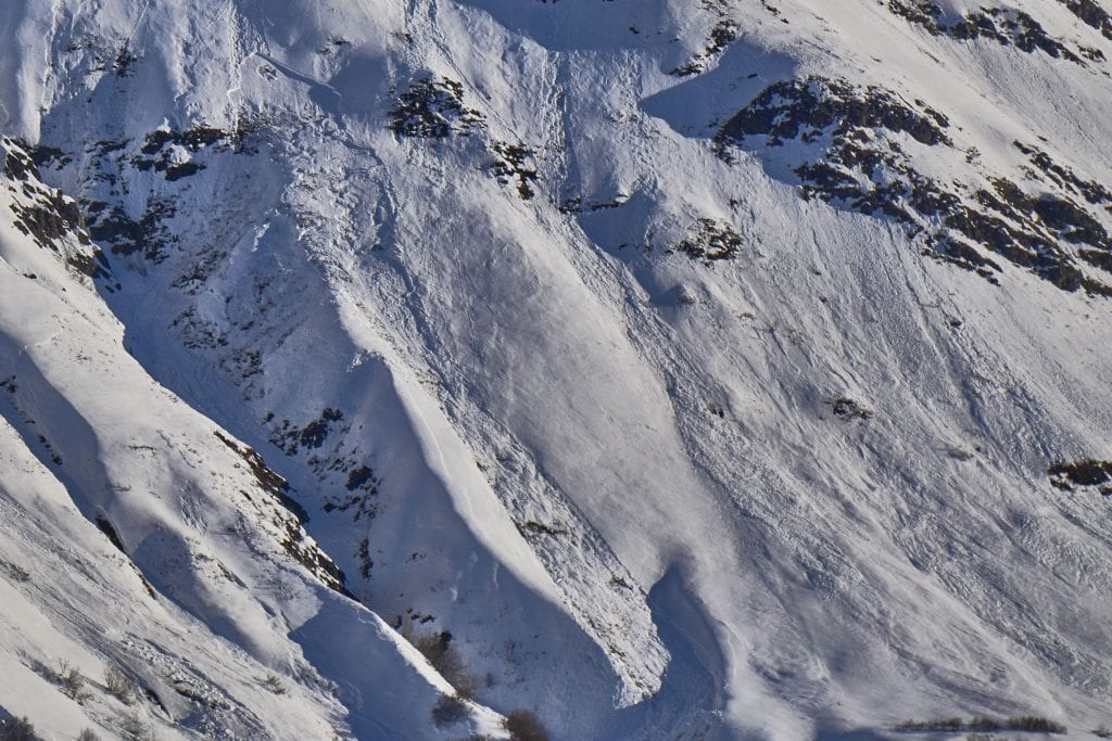
Above: 2/27 (?) Natural wet-loose that triggered a slab avalanche on Idaho Pk, S/SW aspect 3500′.
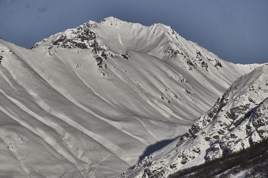
Above: 2/28 Natural wet-loose activity on Teacup, SW aspect 5000′.
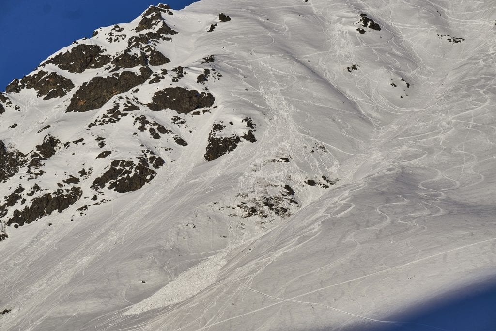
Above: 2/28 Human triggered wet-loose on Marmot, SE aspect 3900′.
Above: 2/28 Human triggered wet-loose on Corporate Ridge of Marmot, S aspect 3400′.
The snowpack is locked up from a good overnight freeze. Temperatures today are forecasted to remain cool up to 4500 feet. Wet avalanches will be unlikely today.
As temperatures rise in the afternoon, continue to monitor afternoon warming. The most likely place for any wet avalanche activity would be on S through SW aspects, on slopes 40° and steeper, in steep, shallow, rocky areas, at all elevations.
Although unlikely, wet-loose avalanches may be possible in isolated areas or extreme terrain. Small wet loose avalanches may be able to sweep you off your feet, carrying you into terrain traps, and compounding the hazard.
Above: 2/28 Human triggered wet-loose on Corporate Ridge of Marmot, S aspect 3400′.
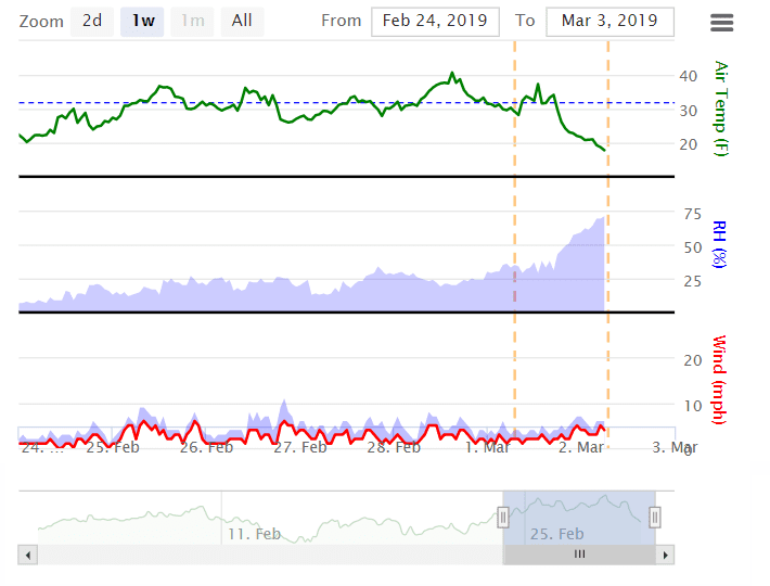
Above: Several warm days and barely freezing at night until 3/2.
More wet-loose information HERE.
Dry loose avalanches will be small and possible to human trigger on slopes 40° and steeper on Northerly aspects at upper elevations.
This week’s weather at Independence Mine 3550′:
Temps averaged 27ºF, with a low of 15ºF and a high of 40ºF.
No new snow this week.
Overnight at 3550′:
Temps averaged 21°F.
No new snow.
This week’s weather at Marmot Weather Station 4500′:
Temps averaged 31ºF, with a low of 20ºF and a high of 41ºF.
Winds averaged SE 2 mph, max 6 mph . Gusts averaged SE 4 mph, max gust SE 11 mph.
Overnight at 4500′:
Temps averaged 21ºF overnight, with a Low of 19ºF.
Winds averaged SSE 4 mph overnight. Max gust SSE 7mph.
NWS Rec Forecast HERE
NWS point forecast HERE
State Parks Snow Report and Motorized Access information HERE
TREND – remaining the same


