
Hatcher Pass
|
|
The avalanche danger is Moderate today in the morning for Wet Avalanches at mid and low elevation. Danger will rise to Considerable for Wet Avalanches at mid and low elevation on steep SE to SW aspects in the afternoon and into tomorrow if we continue to see above freezing temperatures overnight.
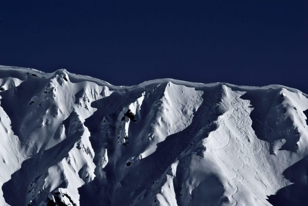
Cornices are huge and sensitive and will be possible for a human or dog to trigger today. Cornices will have the potential to trigger larger sluffs or slab avalanches that may fail to the ground.
Record high temps have thrown the snowpack into a spring cycle. Timing will be key to finding enjoyable skiing/riding and avoiding avalanches today. Early bird gets the worm!
Announcements:
Heading to Turnagain? Be sure to check the CNFAIC Forecast HERE.
Want to support avalanche education in Alaska? Head to the Alaska Avalanche School Ski-Mo (uphill/downhill) fundraiser race at Arctic Valley on Sunday, March 24th at 1pm. For more information click HERE.
| |
|
|
|
|
|
| Travel Advice | Generally safe avalanche conditions. Watch for unstable snow on isolated terrain features. | Heightened avalanche conditions on specific terrain features. Evaluate snow and terrain carefully; identify features of concern. | Dangerous avalanche conditions. Careful snowpack evaluation, cautious route-finding, and conservative decision-making essential. | Very dangerous avalanche conditions. Travel in avalanche terrain not recommended. | Extraordinarily dangerous avalanche conditions. Avoid all avalanche terrain. |
| Likelihood of Avalanches | Natural and human-triggered avalanches unlikely. | Natural avalanches unlikely; human-triggered avalanches possible. | Natural avalanches possible; human-triggered avalanches likely. | Natural avalanches likely; human-triggered avalanches very likely. | Natural and human-triggered avalanches certain. |
| Avalanche Size and Distribution | Small avalanches in isolated areas or extreme terrain. | Small avalanches in specific areas; or large avalanches in isolated areas. | Small avalanches in many areas; or large avalanches in specific areas; or very large avalanches in isolated areas. | Large avalanches in many areas; or very large avalanches in specific areas. | Very large avalanches in many areas. |
Numerous natural and human triggered wet-loose avalanches were observed most of the week. Most wet-loose were small in size, in terrain 40° and steeper, and on ALL aspects, and all elevations. The largest avalanches were up to D1.5 in size and on SE to SW aspects.
A notable cornice fall on 3/21 (triggered by a dog) triggered the persistent slab on a NW aspect at 4500’ on 3/21. The pocket failed to the ground and was D1.5. The dog is reported to be fine.
For more info and pictures on the Natural and Human triggered avalanches this week , check out the mid week summary, HERE or weekly OBSERVATIONS HERE.


This past week of unruly warm weather has thrown hatcher pass into a wet-avalanche cycle. Mostly small wet-loose sluffs will be possible on steep slopes, on mostly SE to SW aspects in the morning, at mid and low elevation. Avalanche activity will rise to considerable, human triggered likely, naturals possible, at mid and low elevation in the afternoon, on steep slopes, mostly SE to SW aspects. We are right at the tipping point of seeing more frequent and larger wet avalanches, up to D2 in size.
The good news: Wet loose avalanches are predictable and avoidable. Timing is everything. The bad news: Spring appears to be here a month early and it is not freezing below 3000’ at night.
Pay attention to rollerballs gaining momentum, sinking in up to your shins in the snowpack, and watch for wet loose activity on other aspects and terrain. These are all great clues the wet avalanche hazard is rising and indicators that it’s time to move to shadier and less saturated slopes to travel on. This may mean you are left with some light at the end of the day, temps will be comfortable outdoors, so head to the car for a tailgate party instead of pushing this hazard too far.
 Above: 3/19 ,Wet loose avalanches. Microdot, 4500′, S aspect.
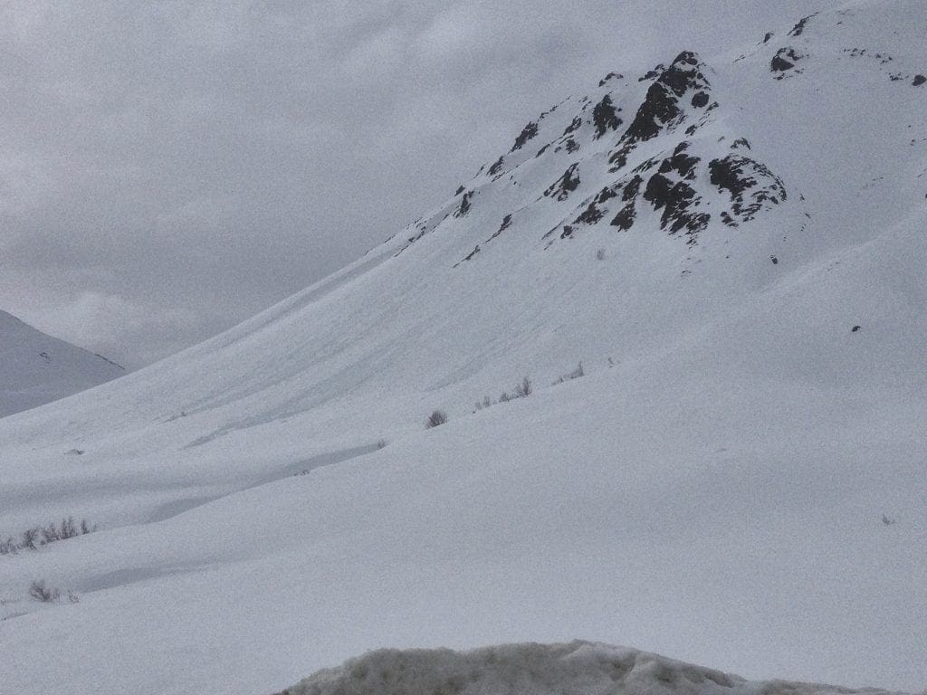
Above: 3/20 or 3/22, Natural wet-loose, SW aspect Skyscraper, 3900′.
More about wet avalanches in the avalanche problem toolbox, HERE.
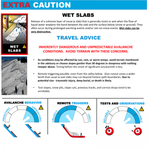
With 3 nights of temperatures above freezing at 3000’ and below, the wet-slab hazard may rise today in the afternoon at mid-elevation, on SE to SW aspects, on slopes 40° and steeper. Wet slabs are hard to predict. Wet slabs are becoming more and more likely to occur with this warm weather trend at mid elevation where the snowpack structure is shallower, and has a slab sitting on crusts over weak basal facets and depth hoar. If temperatures continue to increase this weekend, wet slabs may increase from a moderate to considerable danger in the above mentioned locations. Wet-slabs could be up to D2 is size, or large enough to bury, injure, or kill a person.
Paying attention to rising temperatures, and lack of overnight freezing are your best red flags for knowing when wet-slabs will occur. Wet-slabs can be remotely triggered and tests can be unreliable.
Wet slabs are unlikely at the upper elevations where temperatures have remained cool overnight, and at the lower elevations where the snowpack structure is mostly weak, lacking a slab component.
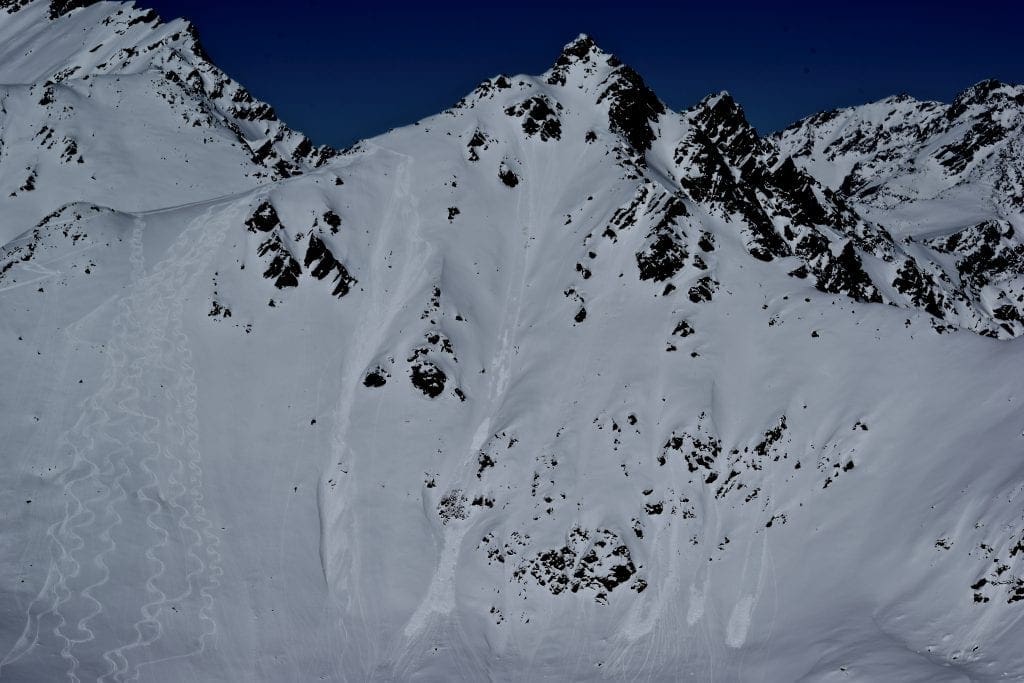
Moderate to strong winds earlier in the week continued to build large cornices that have proven sensitive to human triggers. 3 known sizeable cornice fall events have occured in the past week, including two humans and one dog. All cornice falls triggered avalanches up to D1.5 in size. Let’s remind ourselves that cornices often break farther back than expected. 4 people and 1 dog passed by on the same skin track, nearly 20’ back from a cornice before the 2nd dog triggered the 15′ cornice chunk, leading to a D1.5 persistent slab avalanche. Picture HERE or FB post here.
Low visibility can make judging the size and safe route around cornices difficult. Cornices are extremely unpredictable. Cornices are too large to try to intentionally trigger. Give cornices a wide berth as they can break back much further than expected and will be possible to trigger larger avalanches below. Avoidance is the best mitigation tactic. Minimize your time spent under or near cornices.
Above: Large cornice-fall triggered avalanche occurred March 17. Rae Wallace Chutes, 4500′, N aspect.
Above: Closer view of the crown of avalanche (shown above) and LARGE cornices.
This week’s weather at Independence Mine 3550′: OLD
Temps averaged 36ºF, with a low of 19ºF and a high of 42ºF.
IM recorded 4” of new snow and .4″ water (SWE) this week.
Overnight at 3550′:
Temps averaged 36°F.
No new snow.
This week’s weather at Marmot Weather Station 4500′:
Temps averaged 27ºF, with a low of 14ºF and a high of 35ºF.
Winds averaged ESE 11 mph, max 26 mph . Gusts averaged ESE 19 mph, max gust ESE 53 mph.
Overnight at 4500′:
Temps averaged 31ºF overnight.
Winds averaged E 31 mph overnight. Max gust E 15 mph.
NWS Rec Forecast HERE
NWS point forecast HERE
State Parks Snow Report and Motorized Access information HERE
TREND
Expect warmer temperatures, some clouds and/or scattered snow showers, and winds E 3-12 mph today at 3000′. Avalanche danger will remain the same until temperatures increase again. If we continue to see temps above freezing up to 3000’ overnight, expect wet-avalanches at mid and low elevation to be likely.


