
Hatcher Pass
|
|
This is not an Avalanche Advisory. This information is a Conditions Update. The next avalanche advisory is scheduled for Saturday December 15, 2018.
SNOW AND AVALANCHE CONDITIONS SUMMARY
A fast moving storm brought 8” of snow Saturday night to Hatcher Pass. The new snow added stress to a thin snowpack, creating a dangerous avalanche prone set-up. Sunday afternoon multiple large avalanches were remotely and human-triggered on Hatch Peak, Marmot Peak, and Eldorado Bowl. The avalanche on Hatch Peak buried two skiers, but luckily both were recovered with no injuries. No other burials or injuries were reported. All of these avalanches were on 35 degree, and steeper slopes, but several were triggered from lower angle terrain that was connected. All of the activity was observed in terrain above 3500’, but this does not mean lower elevations are not suspect. On Monday, observers experienced whumphing, shooting cracks and were able to trigger a D2 slab avalanche from a safe location. There is about 1″ of snow in the NOAA forecast through Friday, but there is disagreement between the weather models right now. While stability has increased over time, any new snow or wind will add stress to the snowpack and potentially tip the balance, resulting in sensitive snowpack similar to what we saw last Sunday.
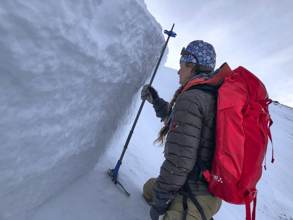
Forecaster Allie Barker investigates the crown of the avalanche on Hatch Peak.
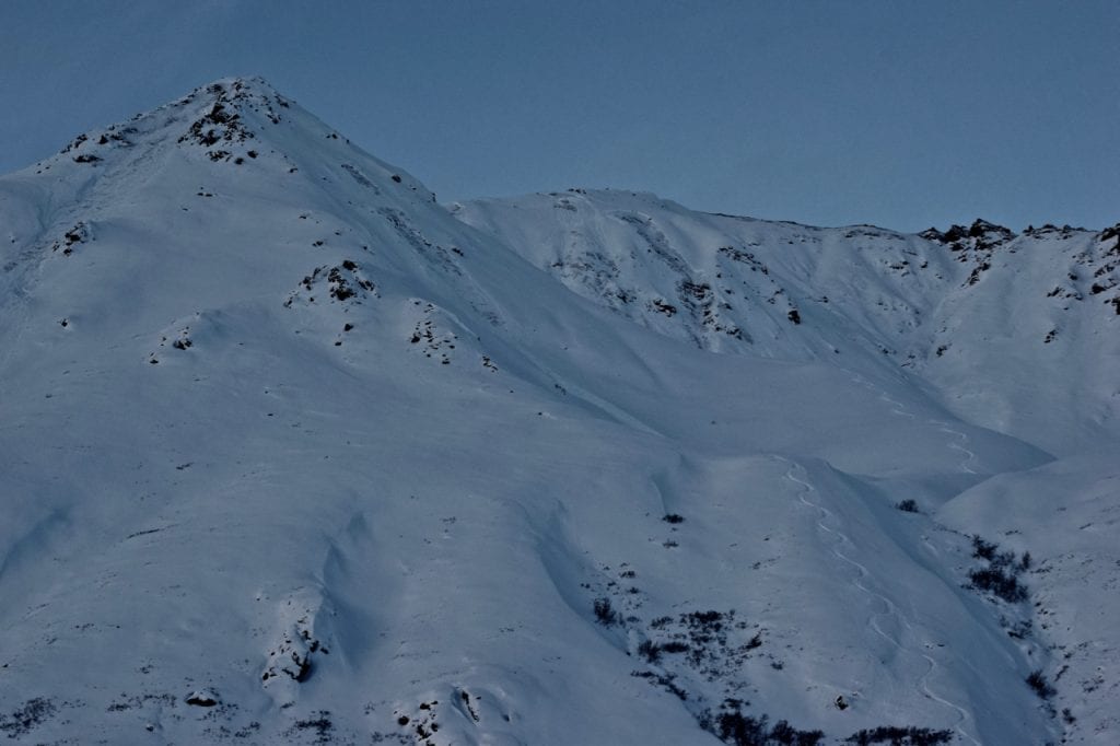
Avalanches in Eldorado Bowl that were humanly and remotely triggered on Sunday.
Early season we saw a lot of snow fall at upper elevations with rain falling at lower elevations. As a result we have a thicker snowpack up high. It will be difficult to assess instability as you ascend in elevation because the snowpack will transition rapidly at upper elevations to a thicker snowpack. Avoid traveling on or underneath 35 degree, and steeper, slopes and be aware of the consequences if the slope slides. Careful snowpack evaluation, cautious route-finding, and conservative decision making is essential. Be wary of even small terrain with high consequence runouts into terrain traps. Be on the lookout for recent avalanches, whumphing/collapsing, shooting cracks, and rapid loading from new snow or wind. These are all red flags for dangerous avalanche conditions. Keep in mind that the current persistent slab avalanche problem may not provide any red flags before an avalanche is triggered. The slope adjacent to the avalanche on Hatch Peak had been skied 10 to 15 times before the avalanche was remotely triggered.
NEW! Midweek Snow and Avalanche Summary 12/13/18
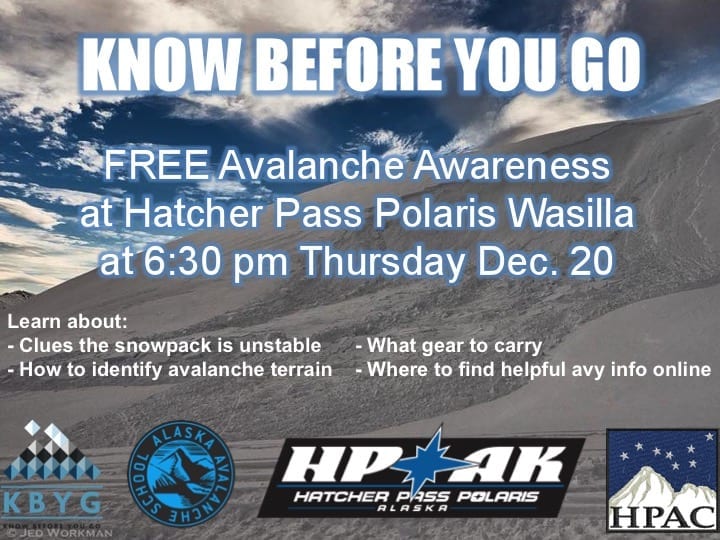
Do you need to tune-up your avalanche skills? Do you want to learn the basics on how to play safely in avalanche terrain? Please join Alaska Avalanche School and Hatcher Pass Avalanche Center Thursday December 20 for a FREE avalanche awareness presentation at Hatcher Pass Polaris Wasilla and Willow at 6:30 pm. All ages are welcome! We hope to see you there!

| |
|
|
|
|
|
| Travel Advice | Generally safe avalanche conditions. Watch for unstable snow on isolated terrain features. | Heightened avalanche conditions on specific terrain features. Evaluate snow and terrain carefully; identify features of concern. | Dangerous avalanche conditions. Careful snowpack evaluation, cautious route-finding, and conservative decision-making essential. | Very dangerous avalanche conditions. Travel in avalanche terrain not recommended. | Extraordinarily dangerous avalanche conditions. Avoid all avalanche terrain. |
| Likelihood of Avalanches | Natural and human-triggered avalanches unlikely. | Natural avalanches unlikely; human-triggered avalanches possible. | Natural avalanches possible; human-triggered avalanches likely. | Natural avalanches likely; human-triggered avalanches very likely. | Natural and human-triggered avalanches certain. |
| Avalanche Size and Distribution | Small avalanches in isolated areas or extreme terrain. | Small avalanches in specific areas; or large avalanches in isolated areas. | Small avalanches in many areas; or large avalanches in specific areas; or very large avalanches in isolated areas. | Large avalanches in many areas; or very large avalanches in specific areas. | Very large avalanches in many areas. |
Since the start of December, 2+ feet of snow has fallen on top of a thin snowpack containing persistent weak layers of loose facets above and below a decomposing melt-freeze crust. In places where the snow has been compacted by the wind, namely northerly aspects, a strong, hard slab has formed that is more than 3 feet thick in specific locations.
It will be easy to identify the structural snowpack problem, but difficult to predict the exact location for triggering an avalanche. Probing with a ski pole or digging hand pits are good techniques for identifying strong, cohesive slabs overlying weaker, faceted snow. The most likely slope angle for avalanches to occur is 35*+. The tricky part of the equation is you will be able to trigger these avalanches from any connected terrain. For example, you may be on flat terrain and trigger an avalanche on a steeper slope above you, or adjacent to you. Uncertainty is the name of the game, so hedge your bets with a large margin for error. The current conditions are very tricky. Many locations will allow you to collapse the weak layer, with an audible “whumph” but with no avalanche results. In other cases, you may step on a “button” or “sweet spot” and trigger a large avalanche.
This report is a mid-week conditions update, so please be sure to check hpavalanche.org for advisories on Saturdays and follow the HPAC Facebook for updates. Help us keep tabs on the Hatcher Pass area! If you see any avalanche activity send us an observation HERE. Thank you to everyone who has already submitted observations this season – you can see those HERE!
Independence Mine received 8” of new snow (0.8” SWE) between Saturday 12/8 and Sunday 12/9, 2″ of new snow Tuesday night 12/11, and 1.5″ of new snow Wednesday night 12/12. Temperatures dropped rapidly from the mild temperatures of last week to a low of 9 degrees F Saturday night. Temperatures then recovered into the 20’s by Monday afternoon, but again dropped to single digit highs and lows by Tuesday morning. Ridge top temperatures at Marmot weather station were similar. Winds have been relatively benign by Hatcher Pass standards, with calm to light wind at Independence Mine over the last week. Ridge top winds have been light gusting to moderate from the SE since Saturday morning.
The weather through Saturday morning is expected to be much colder than the last week, with highs in the low teens and lows hovering right above 0 degrees F. Wind will continue to be light gusting to moderate, shifting to the East by Thursday. Expect scattered snow showers through Friday with little accumulation. There is disagreement in the weather models right now for precipitation, so it’s possible for Hatcher Pass to get more snow than expected.
Stay tuned to the NOAA forecast for an updated weather forecast each day. The best way to see if it’s snowing in Hatcher Pass is to look at the webcam snow stake HERE and the Independence Mine SNOTEL site HERE.
NWS Recreational Forecast HERE
HP State Park Snow Report and Motorized Access Info HERE


