
Hatcher Pass
|
|
Dangerous avalanche conditions continue at HP. Human triggered avalanches large enough to bury a person will remain possible to likely through this weekend and this week. Unfortunately this season’s snowpack is set up for avalanches, and will be extremely slow to heal or improve.
The avalanche danger is CONSIDERABLE at mid to upper elevations on all aspects on slopes 35º and steeper. Slab avalanches will fail 2-4 feet deep, at or near the ground, on weak, sugary snow. These avalanches may be triggered remotely from any adjacent terrain or the flats below.
Whumphing and shooting cracks are bulls-eye clues that conditions are ripe for avalanches. A highly variable snowpack depth exists, 1-4 feet deep, with the deepest snow in wind loaded areas, and thin coverage in many areas.

| |
|
|
|
|
|
| Travel Advice | Generally safe avalanche conditions. Watch for unstable snow on isolated terrain features. | Heightened avalanche conditions on specific terrain features. Evaluate snow and terrain carefully; identify features of concern. | Dangerous avalanche conditions. Careful snowpack evaluation, cautious route-finding, and conservative decision-making essential. | Very dangerous avalanche conditions. Travel in avalanche terrain not recommended. | Extraordinarily dangerous avalanche conditions. Avoid all avalanche terrain. |
| Likelihood of Avalanches | Natural and human-triggered avalanches unlikely. | Natural avalanches unlikely; human-triggered avalanches possible. | Natural avalanches possible; human-triggered avalanches likely. | Natural avalanches likely; human-triggered avalanches very likely. | Natural and human-triggered avalanches certain. |
| Avalanche Size and Distribution | Small avalanches in isolated areas or extreme terrain. | Small avalanches in specific areas; or large avalanches in isolated areas. | Small avalanches in many areas; or large avalanches in specific areas; or very large avalanches in isolated areas. | Large avalanches in many areas; or very large avalanches in specific areas. | Very large avalanches in many areas. |
Sunday had many human triggered and remotely triggered avalanches. See observations HERE for more information.
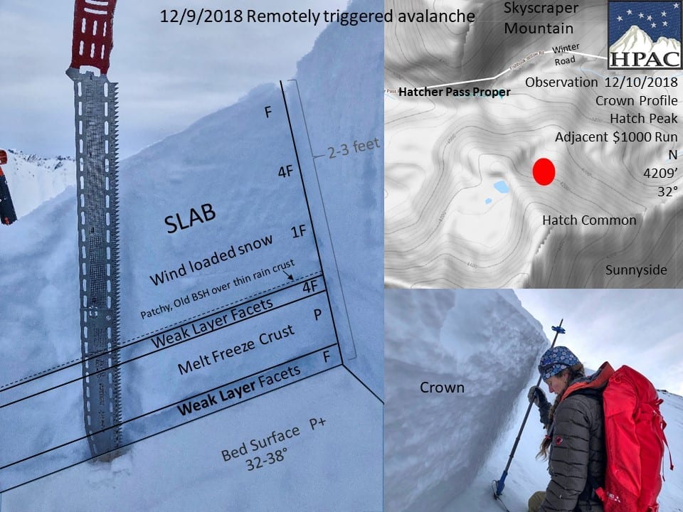
Below: Hatcher Common, crown profile from remotely triggered avalanche burying two people on Sunday, 12/9/2018
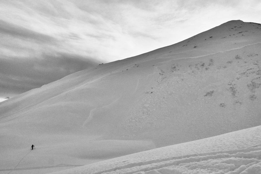
Above: Skier approaches old, remotely triggered avalanche from Sunday, 12/9/2018 on Hatch Common.
This avalanche failed on buried surface hoar and basal facets.
On Monday, forecasters were able to remotely trigger a D2 avalanche below them as they walked along a safe ridgeline, see more information HERE.
Reports have continued to come in this week indicating whumphing and cracking, bulls-eye clues for snow instability.
Widespread persistent weak layers deep in the snowpack will be stubborn to reactive and possible to likely to trigger on all aspects at mid to upper elevations on slopes 35º and steeper. Avalanches are more likely in specific locations, on leeward aspects, generally West to North, where previous wind loading has built slabs 2-4 feet deep. Just about any persistent slab avalanche will be large enough to bury and/or injure a person (D1-2.5).
While stability has increased marginally this week, these weak layers have not gone away and will continue to be problematic this weekend. It will be possible to trigger avalanches remotely, on adjacent terrain, and from the flats below steeper slopes.
Winds are forecasted to be light to moderate today, but overnight and early this morning winds at 4500′ have been trending stronger. With plenty of available low density snow for transport, wind loading today could quickly increase the avalanche hazard and likelihood of triggering avalanches this afternoon. Keep a close eye on wind speeds through the day and watch a for pluming at ridgelines.
A variety of weak layers will all contribute to instability and avalanche potential. Reactive buried surface hoar, 4-8.0 mm, thin faceted layers in the mid-pack, and basal facets at the ground are all layers of concern. Any failure on any of these weak layers may step down to a deeper weak layer or the ground, increasing the size, and therefore the danger of any avalanche.
This problem will be unreliable and difficult to predict. You may assess one area that has good stability, only to change an aspect or turn a corner and unknowingly find dangerous conditions.
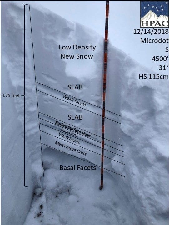
Below: Cross section of snowpit from Microdot, 12/14 (See pit profile HERE)
Below video from testing on Microdot 12/14:
IF YOU GET OUT TO HATCHER PASS THIS WEEKEND, PLEASE SEND US YOUR OBSERVATIONS! HERE
A big thank you to all the people who have sent in observations so far this season, they have been a real asset to the community!
Isolated pockets of stubborn to unreactive wind slabs are at upper elevations, on leeward slopes, generally West to North, are approximately 4″-12″ thick and sit on near surface facets and low density snow. These slabs are just begining to gain enough cohesion to become reactive on slopes 35º and steeper. More wind will further stiffen up these slabs and increase this hazard. This morning’s winds at 4500′ have been steadily increasing.
The forecasted winds are light to moderate through today and overnight and will increase the hazard very slowly. Keep your eye on the wind speeds and watch for plumes at upper elevations ridgelines. Stronger, sustained winds could quickly increase this hazard to considerable.
About 2-3″ of new snow accumulated overnight, bringing the low density height of snow to approximately 13″. This combination of older and new snow sitting on a thin layer of near surface facets will be sensitive to trigger at mid to upper elevations, on all aspects, on slopes 40º and steeper. Sluffs will have the ability to entrain more snow, and possibly enough volume (D1-1.5) to carry you into secondary hazards such as terrain traps.
This week’s weather at 3550′:
Temps averaged 16ºF, with a low of 2ºF and a high of 33ºF.
IM reported about 12″ of new snow with 1″ SWE.
Overnight at 3550′:
Temps averaged 19°F.
3″ new snow.
This week’s weather at 4500′:
Temps averaged 14ºF, with a low of -3ºF and a high of 29ºF.
Winds averaged SE 7 mph, max 29 mph . Gusts averaged SE 13 mph, max gust ESE 47 mph.
Overnight at 4500′:
Temps averaged 14ºF overnight, with a Low of 9ºF .
Winds averaged ESE 11 mph overnight. Max gust SE 26 mph.
NWS Rec Forecast HERE
State Parks Snow Report HERE
TREND
The avalanche hazard should remain the same as persistent weak layers in the snowpack will continue to be reactive and slow to heal. Instability will continue to spike any time the snowpack is rapidly loaded with new snow or wind-transported snow loading.
Wind speeds this morning at 4500´have steadily increased. If this trend continues through today and this weekend, expect the avalanche hazard to quickly rise.


