
Hatcher Pass
|
|
A MODERATE hazard for human triggered avalanches 1-4 feet deep at mid to upper elevations will be possible to trigger this weekend and tricky to predict. Warning signs, such as whumphing and shooting cracks, may not be present.
Avoid steep slopes with terrain traps, and choose slopes with gentle, fanning runouts.
Moderate avalanche hazard does NOT equal safe conditions everywhere. Deciphering the avalanche puzzle will be complex, with large (D2), human triggered avalanches possible on a multitude of weak layers in the snowpack for an avalanche to choose to fail on.
Moderate avalanche hazard does NOT equal safe conditions everywhere. Deciphering the avalanche puzzle will be complex, with large, human triggered avalanches possible on a multitude of weak layers in the snowpack. Help us give the gift of NO avalanches for Christmas! If you choose to enter avalanche terrain, choose terrain lacking terrain traps.
| |
|
|
|
|
|
| Travel Advice | Generally safe avalanche conditions. Watch for unstable snow on isolated terrain features. | Heightened avalanche conditions on specific terrain features. Evaluate snow and terrain carefully; identify features of concern. | Dangerous avalanche conditions. Careful snowpack evaluation, cautious route-finding, and conservative decision-making essential. | Very dangerous avalanche conditions. Travel in avalanche terrain not recommended. | Extraordinarily dangerous avalanche conditions. Avoid all avalanche terrain. |
| Likelihood of Avalanches | Natural and human-triggered avalanches unlikely. | Natural avalanches unlikely; human-triggered avalanches possible. | Natural avalanches possible; human-triggered avalanches likely. | Natural avalanches likely; human-triggered avalanches very likely. | Natural and human-triggered avalanches certain. |
| Avalanche Size and Distribution | Small avalanches in isolated areas or extreme terrain. | Small avalanches in specific areas; or large avalanches in isolated areas. | Small avalanches in many areas; or large avalanches in specific areas; or very large avalanches in isolated areas. | Large avalanches in many areas; or very large avalanches in specific areas. | Very large avalanches in many areas. |
No new avalanche activity since Wednesday as noted in the Mid-Week report listed below:
Natural avalanches were reported Monday-Wednesday on Lower Microdot (NW aspect), Marmot SW aspect, Hatch Peak NE aspect, and Martin Mine Gully NE aspect. See photographs below.
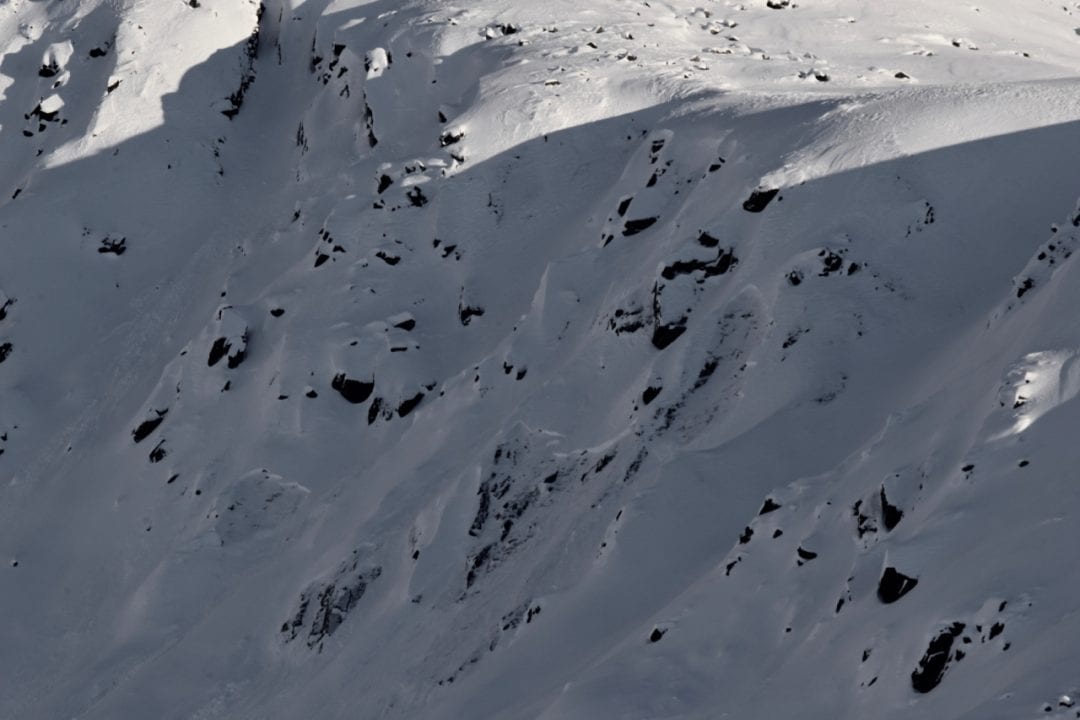
Above: Natural avalanches on Lower Microdot NW aspect on Wednesday 12/19
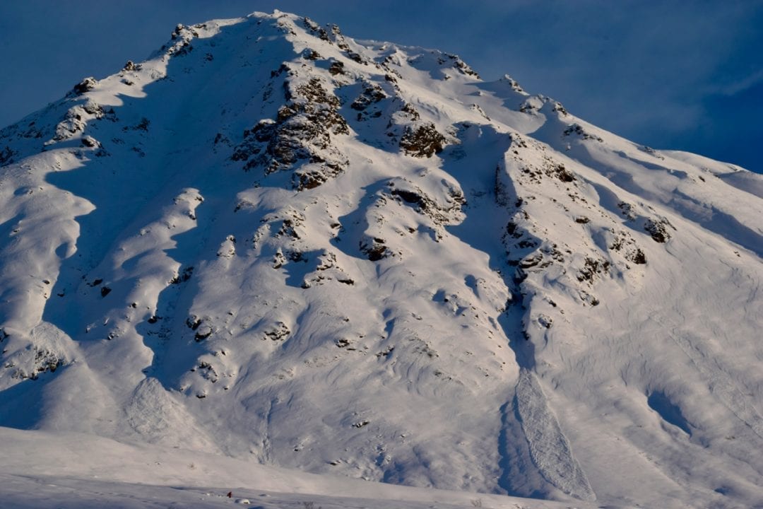
Above: Natural avalanches observed on Marmot W to SW aspects on Wednesday 12/19
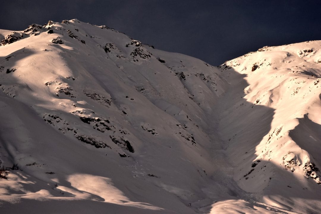
Widely propagating natural avalanche on NE aspect of Martin Mine Gully on Monday 12/17
Stability has increased very slowly over the last two weeks, and significant flaws in the architecture of the snowpack remain. While the probability of triggering an avalanche has decreased, the consequences have not. Avalanches will be possible and difficult to predict.
A MODERATE avalanche hazard at mid to upper elevations exists on all aspects but predominantly on previously wind loaded, 35º+ slopes, generally, West to North, at upper elevations, where stubborn to trigger, soft and hard PERSISTENT SLABS , 2-4 feet deep sit on a variety of widespread and high continuity weak layers within the snowpack, including basal facets, facets above a melt freeze crust, and buried surface hoar. Persistent slab avalanches may be large enough to bury, injure or kill a person (D2). In isolated locations at upper elevations, it may be possible to trigger hard slab avalanches from below, and/or on flat, connected or adjacent terrain.
The current avalanche hazard at HP will be tricky to assess for the average user and challenging for experts. You may assess one area that has good stability, only to change an aspect or turn a corner and unknowingly find more dangerous conditions. When the snowpack demands this level of puzzle mastery, it’s time to hedge our bets by choosing terrain that is forgiving and leaves us with plenty of room for error. Safer terrain and is found on slopes 25º and less and out of the runnout of steeper slopes from above. Avoid large slopes with terrain traps, such as cliffs, rocks, and constrained terrain such as ravines, gullies and creeks. Use safe travel protocol when in or under avalanche terrain.
Dangerous terrain trap. A low probability, but high consequence situation. Here is a video showing a large slope, that if triggered, would flush all of its volume into a tiny ravine at the base of the run. Hatcher Pass is full of similar terrain, and many of these are locations of past avalanche fatalities. Triggering an avalanche in this type of terrain leaves little chance for surviving an avalanche.
Extended Column Test (ECT) below on Marmot Mountain. This video first shows the stubborn, old, wind slab hazard and then shows the high energy, propagating, persistent slab, which is the primary concern:
Isolated pockets of stubborn to unreactive wind slabs are 4-10″ thick sitting on low density snow and near surface facets at upper elevation ridgelines and cross loaded features, on leeward slopes, generally West to North. Wind slabs will be stubborn to unreactive to trigger on slopes 35º and steeper and will generally be small in size. Be cautious as triggering a small winds slab may be able to carry you into terrain traps.
Wind slabs are on the surface of the snowpack and can sound hollow and drummy, indicating stiffer snow overlying weaker snow. Pole or probe testing can easily reveal stiffer snow overlying weaker layers.
Light winds are forecasted today and overnight. Keep your eye on the wind speeds and watch for plumes at upper elevations ridgelines. Stronger, sustained winds could increase this hazard.
Pictured below: Localized cracking, triggered from stomping with skis, on the SW side of Marmot Mountain ridgeline, about 4000′, with two different, old wind slab layers:
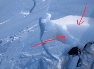
Stiff wind slab appearance below.
This week’s weather at 3550′:
Temps averaged 18ºF, with a low of 8ºF and a high of 29ºF.
IM reported no new snow.
Overnight at 3550′:
Temps averaged 24°F.
No new snow.
This week’s weather at 4500′:
Temps averaged 16ºF, with a low of 8ºF and a high of 24ºF.
Winds averaged E 7 mph, max 20 mph . Gusts averaged E 12 mph, max gust SE 32 mph.
Overnight at 4500′:
Temps averaged 21ºF overnight, with a Low of 18ºF.
Winds averaged E 17 mph overnight. Max gust E 15 mph.
NWS Rec Forecast HERE
State Parks Snow Report and Motorized Access information HERE
TREND
NWS is forecasting cool temps, no new snow and light winds today and overnight. This kind of mediocre Alaska weather will not increase the avalanche hazard today.
Instability will increase with any new, rapid load, such as precipitation and/or wind loading. Keep a close eye on the weather, as our current snowpack only needs a little extra load to increase the avalanche hazard again.


