
Hatcher Pass
|
|
BOTTOM LINE
A Moderate avalanche hazard for persistent slab avalanches and dry loose avalanches exists at mid to upper elevations.
-Persistent slabs 1-3 feet deep exist on all aspects, on slopes 35° and steeper. Natural avalanches unlikely; human-triggered avalanches possible.
-Dry loose avalanches will be moderate in size and possible to human-trigger on slopes 40° and steeper. Direct sunshine on southerly aspects near rock bands may naturally trigger small, loose dry avalanches.
A Low hazard exists at low elevation. Natural and human triggered avalanches unlikely.
Storm snow this week brought 35” of new snow to Hatcher Pass. Dangerous, and widely propagating, avalanche activity spiked during and shortly after the storm. Click here for more information.
Stability has improved, but poor structure in the snowpack remains and will still allow for triggering slab avalanches in isolated locations. It will be difficult to predict where slab avalanches can be triggered.
We recommend using terrain progression. Start on small test slopes, and get a handle on the stability in your area before stepping it up. Avoid slopes with terrain traps, where even small avalanches could have high consequences.

| |
|
|
|
|
|
| Travel Advice | Generally safe avalanche conditions. Watch for unstable snow on isolated terrain features. | Heightened avalanche conditions on specific terrain features. Evaluate snow and terrain carefully; identify features of concern. | Dangerous avalanche conditions. Careful snowpack evaluation, cautious route-finding, and conservative decision-making essential. | Very dangerous avalanche conditions. Travel in avalanche terrain not recommended. | Extraordinarily dangerous avalanche conditions. Avoid all avalanche terrain. |
| Likelihood of Avalanches | Natural and human-triggered avalanches unlikely. | Natural avalanches unlikely; human-triggered avalanches possible. | Natural avalanches possible; human-triggered avalanches likely. | Natural avalanches likely; human-triggered avalanches very likely. | Natural and human-triggered avalanches certain. |
| Avalanche Size and Distribution | Small avalanches in isolated areas or extreme terrain. | Small avalanches in specific areas; or large avalanches in isolated areas. | Small avalanches in many areas; or large avalanches in specific areas; or very large avalanches in isolated areas. | Large avalanches in many areas; or very large avalanches in specific areas. | Very large avalanches in many areas. |
Yesterday backcountry users got out an began stepping up terrain choices. Microdot’s southerly aspect was tracked out, including the more committing ski run, Swimming Tim’s.
One human triggered avalanche was reported yesterday. This avalanche was located near Lone Tree Gulch, up the Gold Mint Trail, and was identified by a third hand observer. This avalanche is estimated to have been human-triggered, approximately 200’ wide, and 2 feet deep.
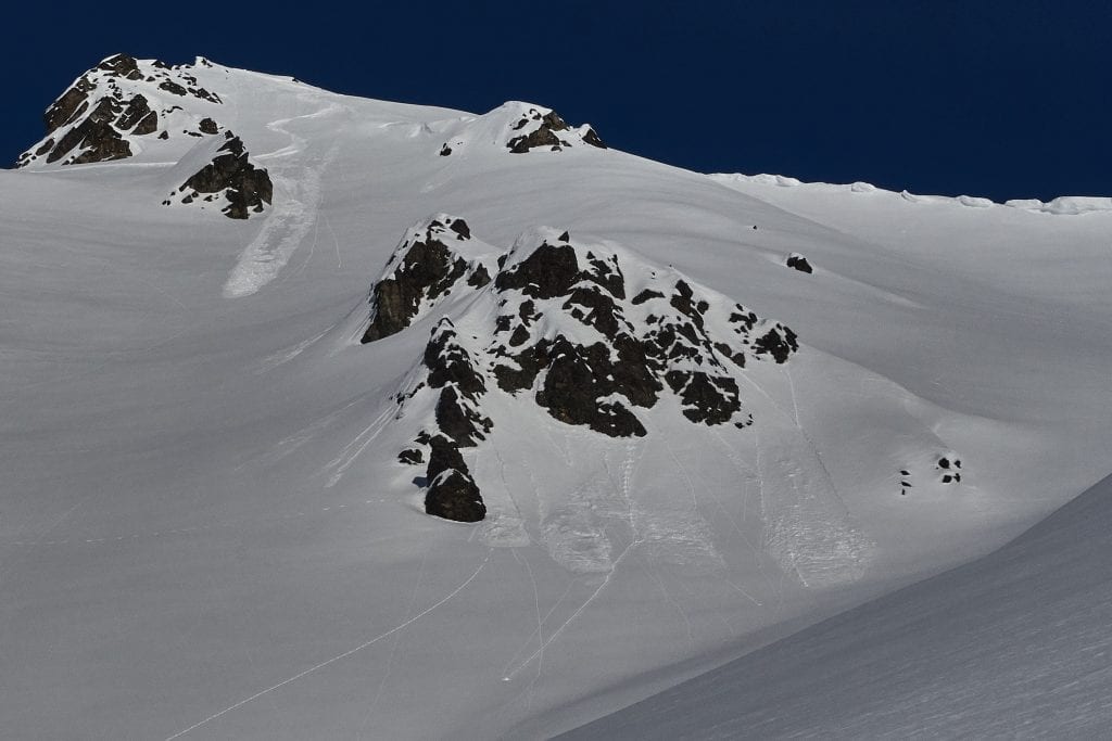
Above: Yesterday small, natural dry loose avalanches were observed on southerly aspects, as well as human-triggered on all aspects. Pictured above: Both natural and human-triggered on a South tilting aspect at 3800′.
Multiple natural avalanches occurred during and shortly after the 2/16-2/19 snow. See more here.
A couple highlights from the week:
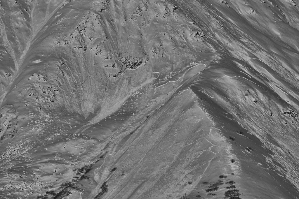
Above: On 2/19 a snowmachiner remotely triggered a very large avalanche near Dog Sled Pass on a SE aspect at 2400-4800’. This avalanche covered the snow machine tracks. The crown was measured on a map to span 2600’, approximately a ½ mile long and estimated to be 2-3 feet deep. This avalanche occurred within 24 hours of a significant storm cycle dumping 35” of new snow on a slippery crust surface (2/5 CNY crust).
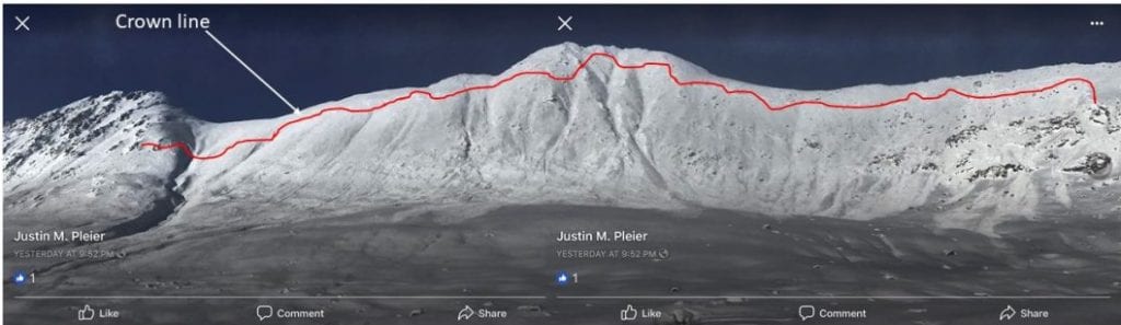
Above: A natural avalanche occurred towards the end of the storm on Divide Ridge on Idaho Peak, S>NW, 2300-4000’, est. 2 feet deep, failing on the CNY crust layer. This avalanche is significant because it widely propagated around multiple ridge features and as
Persistent slabs exist at mid to upper elevations, on all aspects, 1-3 feet deep, and large enough to bury, injure or kill a person. Persistent slabs will be stubborn to unreactive to trigger, and will be more problematic on slopes 35° and steeper, and in thinner locations of the snowpack.
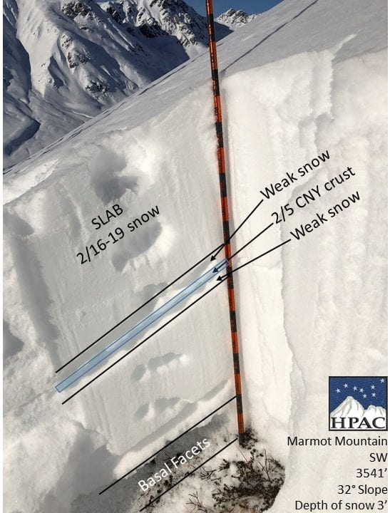
Multiple weak layers exist in the snowpack. However, the primary layer of concern is a slab sitting on the widespread Chinese New Year (2/5 CNY) crust layer which is buried approximately 1-3 feet deep. This layer is estimated to be responsible for most of the avalanche activity this week (see avalanche activity).
Recent observations and testing of this layer are suggesting it is gaining strength and bonding to the snow (slab) above it. If you dig a snowpit, this layer can often be found relatively close to the surface, is easily identified, and allows for timely instability testing. Extended column tests are recommended for testing this layer, as are many hasty tests, such as hand pits, for continued verification of results through the day.
Dry loose avalanches will be possible to human trigger on slopes 40° and steeper. Dry loose avalanches are more likely on North to East aspects. South and West aspects received direct solar radiation yesterday, and may have a faint crust on the surface reducing the chances for dry loose. Even a small dry loose avalanche could sweep you off your feet and carry you into terrain traps, exposing you to a higher risk hazard, such as rocks and cliffs.
This week’s weather at Independence Mine 3550′:
Temps averaged 20ºF, with a low of 10ºF and a high of 26ºF.
35″ of new snow accumulated this week with 2.5″ of water (SWE).
Overnight at 3550′:
Temps averaged 17°F.
No new snow.
This week’s weather at Marmot Weather Station 4500′:
Temps averaged 15ºF, with a low of 4ºF and a high of 21ºF.
Winds averaged E/ESE 5 mph, max 28 mph . Gusts averaged 10 mph, max gust SE 40 mph.
Overnight at 4500′:
Temps averaged 17ºF overnight, with a Low of 15ºF.
Winds averaged SE 3 mph overnight. Max gust NE 10 mph.
NWS Rec Forecast HERE
NWS point forecast HERE
State Parks Snow Report and Motorized Access information HERE
TREND – Slowly improving


