
Hatcher Pass
|
|
UPDATE! Dangerous avalanche conditions. Careful snowpack evaluation, cautious route-finding and conservative decision-making essential.
We are in the middle of a significant new storm system that will continue through tomorrow morning. Up to 2 feet of new snow is expected. Our snowpack is in a delicate balance that may result in natural avalanches up to 1-5 feet deep. The avalanche hazard will continue to increase through today, this evening and into tomorrow morning.
The avalanche hazard is rising to CONSIDERABLE at mid to upper elevations today for storm slab, wind slab, persistent slab, and loose dry avalanches at mid to upper elevations. Human triggered slab avalanches are likely and natural slab avalanches are possible. Loose dry avalanches are likely for both human and natural triggers on slopes 40º and steeper.
The avalanche hazard is rising to MODERATE at low elevation, where slab avalanches may be possible to human trigger and natural slab avalanches are unlikely. Loose dry natural avalanches will be likely for both human and natural triggers on slopes 40º and steeper.
Thanks to everyone who came out and donated to the Annual Cabin Fever Reliever Annual Fundraiser last night! It was a huge success!
| |
|
|
|
|
|
| Travel Advice | Generally safe avalanche conditions. Watch for unstable snow on isolated terrain features. | Heightened avalanche conditions on specific terrain features. Evaluate snow and terrain carefully; identify features of concern. | Dangerous avalanche conditions. Careful snowpack evaluation, cautious route-finding, and conservative decision-making essential. | Very dangerous avalanche conditions. Travel in avalanche terrain not recommended. | Extraordinarily dangerous avalanche conditions. Avoid all avalanche terrain. |
| Likelihood of Avalanches | Natural and human-triggered avalanches unlikely. | Natural avalanches unlikely; human-triggered avalanches possible. | Natural avalanches possible; human-triggered avalanches likely. | Natural avalanches likely; human-triggered avalanches very likely. | Natural and human-triggered avalanches certain. |
| Avalanche Size and Distribution | Small avalanches in isolated areas or extreme terrain. | Small avalanches in specific areas; or large avalanches in isolated areas. | Small avalanches in many areas; or large avalanches in specific areas; or very large avalanches in isolated areas. | Large avalanches in many areas; or very large avalanches in specific areas. | Very large avalanches in many areas. |
Natural avalanche activity is likely beginning today. Low visibility and stormy conditions will make assessment challenging until after the storm.
Numerous natural slab avalanches were observed this week, likely occurring 1/25 to 1/28, 1-2′ deep, up to D2 in size, failing on new snow/old snow interface, West > North > East, in elevations band 4,000′ to 4800′. See observation and PICS here.
Numerous natural dry loose sluffs were observed this week with 7-9.5″ of new, low density snow, the majority of which accumulated on 1/28, on all aspects, on slopes above 40º. Many of the loose dry avalanches occurred during the 1/28 storm, with more natural activity on 1/31 with the first direct solar gain on the new snow.
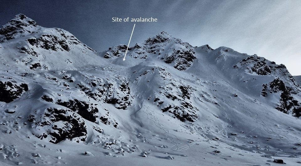
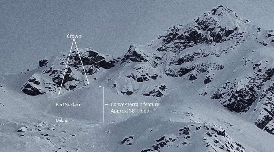
On2/1 – On the northern side of Friendship pass near Dog Sled Pass, a human triggered slab avalanche was reported on a NW aspect, 35-38º slope, 4700′, D1.5. One person was caught and carried, partially buried to their chest, no injuries. 2 pictures below.
A change in the weather pattern which started late last night and will continue through Monday is bringing a substantial snow storm to Hatcher Pass.
As of 3 pm today 7-8” of new snow has accumulated at the IM Snotel site at 3550’. Expect snow totals at upper elevations to be higher, possibly up to 12” so far.
Up to 2 feet of new snow is forecasted for Hatcher Pass by Monday morning.
The Marmot weather station at 4500’ is currently showing Southeast to South wind speeds strong enough to transport snow and build wind slabs on leeward, Northwest to North, aspects. Sustained winds are forecasted overnight.
NWS Rec Forecast HERE
NWS point forecast HERE
State Parks Snow Report and Motorized Access information HERE
TREND
A warming snow storm, new snow and wind will all contribute to increasing the avalanche hazard today through Monday.


